Αρχείο:WINDDISTRIBUTION2.jpg
Από RemoteSensing Wiki
Δεν διατίθεται υψηλότερη ανάλυση.
WINDDISTRIBUTION2.jpg (550 × 494 εικονοστοιχεία, μέγεθος αρχείου: 95 KB, τύπος MIME: image/jpeg)
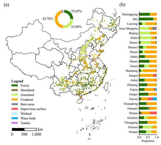
Fig 2. Land use patterns of 63,055 wind turbines. (a) The land use type for each wind turbine and the corresponding proportions (circular chart). (b) Interprovincial variations in land use by wind turbines.
Ιστορικό αρχείου
Πατήστε σε μια ημερομηνία/ώρα για να δείτε το αρχείο όπως εμφανιζόταν εκείνη την ώρα.
| Ώρα/Ημερομ. | Εικονίδιο | Διαστάσεις | Χρήστης | Σχόλια | |
|---|---|---|---|---|---|
| τελευταία | 10:20, 13 Ιανουαρίου 2026 | | 550×494 (95 KB) | Elenikaroutsos (Συζήτηση | Συνεισφορές/Προσθήκες) | (Fig 2. Land use patterns of 63,055 wind turbines. (a) The land use type for each wind turbine and the corresponding proportions (circular chart). (b) Interprovincial variations in land use by wind turbines. ) |
- Επεξεργαστείτε το συγκεκριμένο αρχείο χρησιμοποιώντας μια από τις εξωτερικές εφαρμογές. Για περισσότερες πληροφορίες δείτε τις οδηγίες εγκατάστασης.
Συνδέσεις αρχείου
Η ακόλουθη σελίδα συνδέεται με αυτό το αρχείο: