Αρχείο:Nagna Parbat.jpg
Από RemoteSensing Wiki
(Διαφορές μεταξύ αναθεωρήσεων)
I avgeros (Συζήτηση | Συνεισφορές/Προσθήκες)
(SPOT 3 ortho-rectified NIR image of Nanga Parbat, in Northern Pakistan. The Indus and Astor Rivers are located in the NW and NE portions of the image respectively. The knife-edged Nanga Parbat ridge is oriented in a NE–SW direction and is visible in the)
(SPOT 3 ortho-rectified NIR image of Nanga Parbat, in Northern Pakistan. The Indus and Astor Rivers are located in the NW and NE portions of the image respectively. The knife-edged Nanga Parbat ridge is oriented in a NE–SW direction and is visible in the)
Παρούσα αναθεώρηση της 16:27, 19 Ιανουαρίου 2025
SPOT 3 ortho-rectified NIR image of Nanga Parbat, in Northern Pakistan. The Indus and Astor Rivers are located in the NW and NE portions of the image respectively. The knife-edged Nanga Parbat ridge is oriented in a NE–SW direction and is visible in the lower part of the image.
Ιστορικό αρχείου
Πατήστε σε μια ημερομηνία/ώρα για να δείτε το αρχείο όπως εμφανιζόταν εκείνη την ώρα.
| Ώρα/Ημερομ. | Εικονίδιο | Διαστάσεις | Χρήστης | Σχόλια | |
|---|---|---|---|---|---|
| τελευταία | 16:27, 19 Ιανουαρίου 2025 | 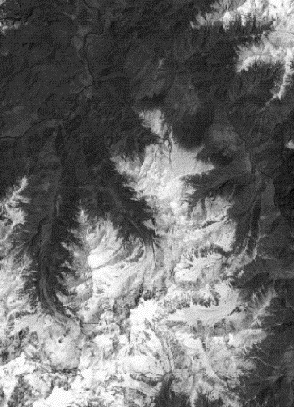 | 329×455 (61 KB) | I avgeros (Συζήτηση | Συνεισφορές/Προσθήκες) | (SPOT 3 ortho-rectified NIR image of Nanga Parbat, in Northern Pakistan. The Indus and Astor Rivers are located in the NW and NE portions of the image respectively. The knife-edged Nanga Parbat ridge is oriented in a NE–SW direction and is visible in the) |
- Επεξεργαστείτε το συγκεκριμένο αρχείο χρησιμοποιώντας μια από τις εξωτερικές εφαρμογές. Για περισσότερες πληροφορίες δείτε τις οδηγίες εγκατάστασης.
Συνδέσεις αρχείου
Η ακόλουθη σελίδα συνδέεται με αυτό το αρχείο: