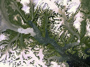
Glacial horn landsat
Από RemoteSensing Wiki
(Διαφορές μεταξύ αναθεωρήσεων)
| Γραμμή 1: | Γραμμή 1: | ||
| - | [[Εικόνα:Kangerdlugssuaq Glacier Greenland by Landsat-7 .jpg|thumb|right|Kangerdlugssuaq | + | [[Εικόνα:Kangerdlugssuaq Glacier Greenland by Landsat-7.jpg|thumb|right|The Kangerdlugssuaq glacier and its ice stream are pictured in this week’s image, acquired on 19 September 2012 by Landsat-7. It is the largest outlet glacier on Greenland’s east coast, discharging ice into the surrounding oceans. In this image we can see hundreds of icebergs speckling the water. A recent study based on satellite observations revealed that over the past 20 years the ice melting in Greenland and Antarctica has contributed about 11 mm to the global sea-level rise. This image clearly shows the glacier’s calving front, where ice breaks away. Over the years, satellite images have shown that this front has retreated – an indication that the glacier is getting smaller over time. ,πηγή:http://minsex.blogspot.com/2012_12_01_archive.html]] |
Αναθεώρηση της 19:07, 29 Μαΐου 2015

The Kangerdlugssuaq glacier and its ice stream are pictured in this week’s image, acquired on 19 September 2012 by Landsat-7. It is the largest outlet glacier on Greenland’s east coast, discharging ice into the surrounding oceans. In this image we can see hundreds of icebergs speckling the water. A recent study based on satellite observations revealed that over the past 20 years the ice melting in Greenland and Antarctica has contributed about 11 mm to the global sea-level rise. This image clearly shows the glacier’s calving front, where ice breaks away. Over the years, satellite images have shown that this front has retreated – an indication that the glacier is getting smaller over time. ,πηγή:http://minsex.blogspot.com/2012_12_01_archive.html
Πυραμιδική κορυφή ή και μερικές φορές στην πιο ακραία μορφή της ονομάζεται παγετώνων κέρατο(glacial horn) είναι μία γωνιακή,απότομη και μυτερή κορυφή ενός βουνού που προκύπτει από κυκλική διάβρωση λόγω των πολλαπλών παγετώνων που αποκλίνουν από ένα κεντρικό σημείο.
Αναγνωρίζεται από:
- Το σχήμα
- Τη σχέση με το περιβάλλον: Βρίσκεται σε περιοχή με έντονη χιονόπτωση(κυρίως περιοχή με παγετώνες)
Φωτοαναγνωριστικά χαρακτηριστικά:
- Απόχρωση(Στο έγχρωμο σύνθετο RGB 321): Καφέ (στις περιπτώσεις χιονόπτωσης ή και παγετού η κορυφή αυτή φαίνεται λευκή λόγω της κάλυψής του από το χιόνι ή τον πάγο αντίστοιχα)
- Είδος τόνου περιγράμματος: Διακριτό
- Σχήμα: Ακανόνιστο
- Σχετικό μέγεθος:Ποικίλο
- Βρίσκεται δίπλα σε: Βουνά
Semantic tags
ID σπουδαστή: rs13027
Όνομα κλειδιού: Glacial horn ikonos
Ελληνικό όνομα κλειδιού: Πυραμιδική κορυφή
Είδος τόνου περιγράμματος: discrete
Σχήμα: []
Μέγεθος: [[]]
Βρίσκεται δίπλα σε: [[]]