Tsunami Hawaii
Από RemoteSensing Wiki
| (2 ενδιάμεσες αναθεωρήσεις δεν εμφανίζονται.) | |||
| Γραμμή 5: | Γραμμή 5: | ||
------------------------------------------------------------------------------------------------------------------------------------------------------- | ------------------------------------------------------------------------------------------------------------------------------------------------------- | ||
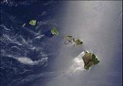
A silver swath of sunlight surrounds half of the Hawaiian Islands in this true-color Terra MODIS image acquired on May 27, 2003. Sunlight reveals turbulence in the surface waters of the Pacific Ocean. In this scene, the winds ruffling the water surface around the Hawaiian Islands create varying patterns, leaving some areas calmer than others. From lower right to upper left, the Big Island (Hawaii), Maui, Kahoolawe, Lanai, Molokai, Oahu, Kauai, and Niihau islands all make up the state of Hawaii, which lies more than 2,000 miles from any other part of the United States. The small red dot on the Big Island's southeastern side marks a hot spot on Kilauea Volcano’s southern flank. | A silver swath of sunlight surrounds half of the Hawaiian Islands in this true-color Terra MODIS image acquired on May 27, 2003. Sunlight reveals turbulence in the surface waters of the Pacific Ocean. In this scene, the winds ruffling the water surface around the Hawaiian Islands create varying patterns, leaving some areas calmer than others. From lower right to upper left, the Big Island (Hawaii), Maui, Kahoolawe, Lanai, Molokai, Oahu, Kauai, and Niihau islands all make up the state of Hawaii, which lies more than 2,000 miles from any other part of the United States. The small red dot on the Big Island's southeastern side marks a hot spot on Kilauea Volcano’s southern flank. | ||
| + | ------------------------------------------------------------------------------------------------------------------------------------------------------- | ||
ΑΝΑΓΝΩΡΙΖΕΤΑΙ ΑΠΟ: | ΑΝΑΓΝΩΡΙΖΕΤΑΙ ΑΠΟ: | ||
| + | |||
Το μέγεθος των κυμάτων που κινούνται προς την ακτή. | Το μέγεθος των κυμάτων που κινούνται προς την ακτή. | ||
| Γραμμή 25: | Γραμμή 27: | ||
* Περιβάλλεται από : θάλασσα | * Περιβάλλεται από : θάλασσα | ||
| + | |||
| + | [[category:Υδάτινες Επιφάνειες]] | ||
| + | |||
| + | |||
| + | ---- | ||
| + | '''Semantic tags''': <br/> | ||
| + | ID ΣΠΟΥΔΑΣΤΗ:[[studen"t_name::rs09612]] <br/> | ||
| + | ΟΝΟΜΑ:[[preferred_name::Tsunami Hawaii]] <br/> | ||
| + | ΕΛΛΗΝΙΚΟ ΟΝΟΜΑ:[[Greek_name::τσουνάμι χαβάη]] <br/> | ||
| + | ΤΥΠΟΣ ΑΡΘΡΟΥ:[[article_type::photointerpretation_key]] <br/> | ||
| + | Χρώμα σε έγχρωμο ορατό κανάλι: [[color::blue]] <br /> | ||
| + | Υφή: [[texture::smooth]] <br /> | ||
| + | περιβάλλεται απο: [[is_surrounded_by::θάλασσα]] <br /> | ||
| + | ΣΧΗΜΑ:[[shape_2d::indistinct]] <br/> | ||
| + | ΣΧΕΤΙΚΟ ΜΕΓΕΘΟΣ:[[relative_size::big]] <br/> | ||
Παρούσα αναθεώρηση της 11:01, 11 Ιουνίου 2011
Στη φωτογραφία βλέπουμε το τσουνάμι που κινείται προς τη Χαβάη.Στο νησί της Χαβάης έφτασαν τα πρώτα κύματα από το τσουνάμι που προκλήθηκε από τον σεισμό των 8,8 βαθμών της κλίμακας Ρίχτερ που έγινε στη Χιλή.Ωστόσο, οι ειδικοί αναφέρουν ότι το τσουνάμι ήταν μικρότερο απ΄ ότι αναμενόταν όπως και σε άλλες χώρες πλήν της Ιαπωνίας και της Ρωσίας.
A silver swath of sunlight surrounds half of the Hawaiian Islands in this true-color Terra MODIS image acquired on May 27, 2003. Sunlight reveals turbulence in the surface waters of the Pacific Ocean. In this scene, the winds ruffling the water surface around the Hawaiian Islands create varying patterns, leaving some areas calmer than others. From lower right to upper left, the Big Island (Hawaii), Maui, Kahoolawe, Lanai, Molokai, Oahu, Kauai, and Niihau islands all make up the state of Hawaii, which lies more than 2,000 miles from any other part of the United States. The small red dot on the Big Island's southeastern side marks a hot spot on Kilauea Volcano’s southern flank.
ΑΝΑΓΝΩΡΙΖΕΤΑΙ ΑΠΟ:
Το μέγεθος των κυμάτων που κινούνται προς την ακτή.
ΦΩΤΟΕΡΜΗΝΕΥΤΙΚΑ ΣΤΟΙΧΕΙΑ:
- Στο παγχρωματικό κανάλι εμφανίζεται πριν χτυπήσει με μπλε χρώμα και άσπρο αφρό.
- Σχήμα: Ακαθόριστο
- Μέγεθος: Ένα τσουνάμι μπορεί να έχει μήκος κύματος 100 έως 200 km (η απόσταση δύο διαδοχικών κορυφών του), ενώ το ύψος του κύματος που προχωράει στον ωκεανό μόλις μισό μέτρο, όμως γιγαντώνεται πολύ γρήγορα. Όταν λοιπόν το κύμα φθάνει στην ακτή, το ύψος του μπορεί να φτάσει και τα 40 μέτρα πάνω από την κανονική στάθμη της θάλασσας.
- Τόνος: Ανοιχτός καθώς τα νερά είναι καθαρά
- Υφή: Λεία πριν το χτύπημα, όπως δείχνει η εικόνα μας.
- Περιβάλλεται από : θάλασσα
Semantic tags:
ID ΣΠΟΥΔΑΣΤΗ:rs09612
ΟΝΟΜΑ:Tsunami Hawaii
ΕΛΛΗΝΙΚΟ ΟΝΟΜΑ:τσουνάμι χαβάη
ΤΥΠΟΣ ΑΡΘΡΟΥ:photointerpretation_key
Χρώμα σε έγχρωμο ορατό κανάλι: blue
Υφή: smooth
περιβάλλεται απο: θάλασσα
ΣΧΗΜΑ:indistinct
ΣΧΕΤΙΚΟ ΜΕΓΕΘΟΣ:big
